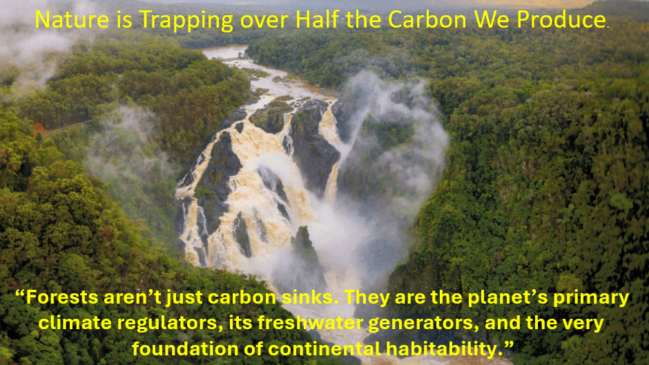
“Here is the uncomfortable truth: Even if we zeroed out carbon emissions tomorrow—a goal certainly worth pursuing—without massive ecological restoration the climate emergency would persist. Forests aren’t just carbon sinks. They are the planet’s primary climate regulators, its freshwater generators, and the very foundation of continental habitability.” Antonio Donato Nobre
We must not degrade native biodiverse forest in Australia for any reason no matter how persuasive the argument seems. We must do all we can to restore and preserve it!
This blog is an adaptation of a short talk I gave at the Cairns & Far North Environment Centre (CAFNEC) Round Table in November 2025.
Picture by Stephen Nowakowski of the Barron River Falls and the surrounding forest.
Forests do a lot of heavy lifting. But what is happening to tropical forests around the world?
Looking at the 3 most important tropical forests around the world, the Amazon Basin is now at a tipping point as a carbon sink. It is barely sequestering more carbon than it produces. The Congo River Basin is still functioning as a net sink despite high levels of clearing. Sadly, South East Asia is now a net carbon producer. A reminder that the carbon emissions from these areas would be much greater without the intact biodiverse forest that still remains.
What about Australia? Recent studies indicate that our tropical forests may reach a tipping point due to various types of disturbance and damage. Unfortunately, the land of south eastern Queensland has already become a net carbon source. Friedlingstein et al 2024; Global Carbon Project 2024
Net Zero Protocols and Targets
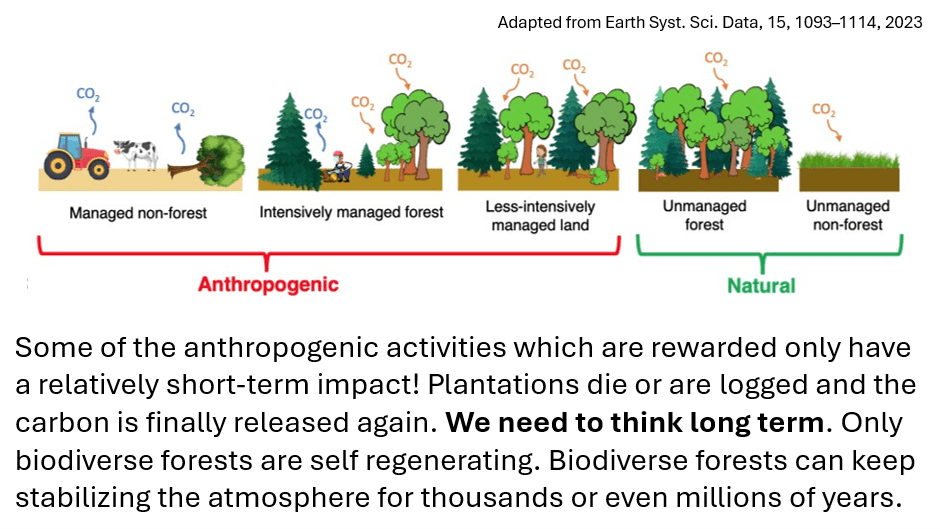
Australia, as did over 100 countries around the world, took on the protocols and targets set by the UN. Each country has been reporting its carbon emissions to the UN according to this plan. This year, only half of these same countries are going to COP30 with the same promises to meet Net Zero Targets. This UN approach to fighting climate change and adopted by Australia is summarized in the diagram below. It is copied from https://www.netzero.gov.au/net-zero. It is my emphasis that has been placed on the word we.
Just how effective is this anthropogenic approach? Well, the world adds a net 5.2 Gt of C to the atmosphere each year.
This diagram illustrates just what is being rewarded under the Net Zero protocol approach. Yet the land with its forests removes 3.2 GtC each year. Millions and millions of dollars have been pumped into the second two technologies for years now and maybe, just maybe, they may eventually have a real effect on carbon emissions. But, in the meantime, we destroy the very thing that it actually working hard for us.
Under the Net Zero protocols, biodiverse forest is not really counted or rewarded.
An example, after a bushfire, if the fire was not too hot, the forest will regenerate and even would benefit from a little help – no reward. But, if the area is cleared and a plantation is developed, the developer can get lots of saleable carbon credits. The former may continue to sequester carbon for little or no cost and keep doing so for thousands or even millions of years. The latter costs more money, sequesters carbon really well for a generation or so but may end up as a zero-sum game.
If good quality biodiverse forest is knocked down, the carbon accounting systems only records a small penalty for change of land use, but little or no accounting is made for the loss of sequestration that would have continued for hundreds of years.
Why are our Forested Areas becoming Net Carbon Sources Instead of Net Carbon Sinks?
This classic diagram provides a hint.
A biodiverse forested area is a living ecosystem. When too much disturbance happens, the tipping point can occur well before 50% disturbance occurs. In Australia, wind turbines are being built by destroying mountain top forest. The impacted area is far greater than the area cleared. The clearing changes micro weather patterns. Uncovered soil is hotter and the surrounding soil and forest also dries. The mists that used to form on the mountain tops become less frequent and the vegetation changes, becomes more fire-prone, invasive species seize the opening, the biodiversity changes and bats no longer pollinate the trees and spread seeds.
Basically, we are rewarding anthropogenic activities that only last for a generation or two. We must start thinking long term. The following diagram shows the sorts of activities that are rewarded. We ignore the “natural” and even give little weight to the less intensively managed forest.
Biodiverse Forests are More than Simply Carbon Sinks
I found some wonderful words by a retired Brazilian scientist who has summarised the issues so eloquently. I presented some of his words in my presentation in 2 slides as shown below.
The cost is more than money. We blithely talk about protecting biodiversity in Australia. Are we doing so? What is the true impact on Climate Change when we buy renewables made overseas using coal fired power? Greenhouse emission data commonly quoted do not apply as they were calculated using nuclear and renewable energy for their production in Europe.
The Wet Tropics is where I have chosen to live now and every day I am still learning more and more about this special region. Much of the information in this blog has been copied from Terrain NRM websites: https://terrain.org.au/ and https://www.wettropicsplan.org.au
The Terrain NRM website is full of information, and it is obvious that a lot of time and careful thought was used in its creation. I loved their descriptions of this region. Hence, I have chosen to copy and paste a few sections that I particularly wish to emphasise. The website is now a few years out of date unfortunately.
There are now new threats to this special area that are not described on the Terrain website so in my next few blogs I will be writing about some of these issues. I will also be writing about the role Australia’s natural world plays in climate change and carbon sequestration.
I should note that I am currently Treasurer for an offshoot of Terrain, the Wet Tropics Soilcare group. This group of farmers care for the biota in the soil, reducing fertilizer use while increasing carbon and water in the soil thus protecting the Great Barrier Reef while producing more and better-quality food.
Terrain NRM is an independent, not for profit and community-based environmental management organisation. We think innovatively and act collaboratively, combining the latest science with local knowledge to develop sustainable solutions to increase the resilience of the rainforests, reefs, landscapes and local communities of Australia’s Wet Tropics region.
If you wanted one word to describe the Wet Tropics Region – it would be DIVERSITY.
Have you ever seen a cassawary in the wild?
Photo credits Terrain NRM
The Wet Tropics region is a melting pot of variety with elevated tablelands, vast outback savannah areas and eye-achingly green coastal floodplains nestled between the foot of the highest peaks in Queensland and the Coral Sea.
The region extends from the iconic Daintree forests of the north to the sugarcane land delta of the Herbert River catchment in the south and then west to the dry rangelands of the Upper Herbert.
The Wet Tropics is literally where the rainforest meets the reef.
This is the only place in the world where two World Heritage Areas are located directly adjacent to one another – the Wet Tropics and the Great Barrier Reef.
The great diversity in the rainfall, geology, soils, topography, drainage and altitude has resulted in a complex and extremely varied spectrum of plants and animals as well as many unique landscapes crafted by nature as well as human activity.
It is a region of contrasts.
The community of the Wet Tropics
Over 250,000 people call the Wet Tropics home and work in a variety of industries. The tourism and primary industries sectors form the foundation of the region’s economy.
Cairns is the largest urban centre in the Wet Tropics region with a population of over 150,000 people from 35 nationalities.
The Wet Tropics is home to a rich, vibrant and enduring Indigenous Rainforest Cultural Heritage, handed down since millennium within the many different Traditional Language Groups. These comprise 20 Traditional Owner Tribal groupings with over 100 clans and family groupings. Over 80 legal entities represent Land People and Culture.
In November 2012, the Wet Tropics World Heritage Area was re-listed to formally include its cultural values. This listing recognises that Rainforest Aboriginal heritage is unique to the Wet Tropics and is a remarkable and continuous Indigenous connection with a tropical rainforest environment.
Wet Tropics Biodiversity
Because of the enormous diversity in altitude and climate, the Wet Tropics region is truly a biodiversity hot spot of global significance.
Directly descended from Gondwana Land, pockets of rainforest in this region have survived 8 major stages of evolutionary change over 415 million years and have more life forms with primitive characteristics than anywhere else in the world.
These origins, along with the varied climate and the dramatic shape of the land, combine to create the perfect conditions for mega-biodiversity.
The Wet Tropics contains half of Australia’s bird species, one third of the continent’s mammals and about 3,000 plant species.
Endemic and Rare Species
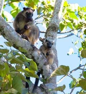
The Wet Tropics is home to numerous endemic species, which means that they are found nowhere else in the world; many are rare and threatened plants and animals. Of particular interest is the Southern Cassowary, the Mahogany Glider and the Lumholtz Tree Kangaroo, a kangaroo which actually lives in the treetops of the threatened Mabi Forest.
The endemic and rare species don’t all live in protected areas. Visit the Rainforest Reserves website and learn about the Magnificent Brood Frog or the Northern Greater Glider or the Red Goshawk threatened by the Chalumbin Wind Project. https://www.rainforestreserves.org.au/
The ecosystems of the Wet Tropics region have also evolved over thousands of years through active Aboriginal interaction with the land and management of its resources. The plants and animals of the region are a fundamental and integral part of many aspects of the life and culture of Traditional Owners.
Biodiversity and Climate Change
Due to its diversity and the unique warm and wet climatic conditions and altitudinal variation, it is anticipated that the Wet Tropics region will be a really important refuge for quite a number of species in a changing climate. For example, species from further west may move into the Wet Tropics as it becomes drier. Species that currently call the coastal areas ‘home’ may move up the mountain slopes to cooler locations.
Threats to Biodiversity
Although 35% of the Wet Tropics region is in the World Heritage Area, the precious and unique plants and animals are still not adequately protected. There are many threats which, unless dealt with, will continue to erode the extraordinary biodiversity values of this region.
Habitat destruction and fragmentation are top of the list as they destroy ‘homes’ and limit the ability of animals to move and interbreed. Pests and weeds, which are rampant in this warm and wet climate, are another significant threat, while pollution, changing fire regimes and changes to waterways also play a part.
Protecting Biodiversity
Australia is in a unique position to protect the biodiversity of this region. Of the 17 ‘megadiverse’ countries, only 2 are developed. Australia’s low population and continental sovereignty provide a unique opportunity for Australia to be world leaders in the protection of the amazing spectrum of plant and animal life that call this region home.
Everyone has a role to play in keeping their footprint as light as possible, respecting the right of other species to exist and flourish, as well as sharing information about the importance of our plants and animals with future generations. The ecological, economic, cultural and social fabric of our Wet Tropics lives depends on this.
The Wet Tropics Bioregion
The Wet Tropics Bioregion, although only accounting for 0.26% of the total area of Australia, conserves a large proportion of Australia’s biodiversity, as demonstrated in the table below (from Goosem, 2002).
% of Australian Total
Wet Tropics Bioregion land area
0.26%
Animals
Mammals
35%
Birds
40%
Frogs
29%
Reptiles
20%
Freshwater fish
42%
Butterflies
58%
Plants
Vascular plants
26%
Ferns
65%
Cycads
21%
Conifers
37%
Orchids
30%
NB: the Wet Tropics bioregion (ca. 2 million hectares) does not fully align with the Wet Tropics NRM region (2.2 million hectares), and notably does not include the Upper Herbert .In either case, the rivers of this area all flow into the Great Barrier Reef.
Goosem, S. (2002). “Wet Tropics of Queensland World Heritage Area – including an Update of the Original Wet Tropics of Queensland Nomination Dossier”. Wet Tropics Management Authority, Cairns, QLD.
Our People of the Forest
Many Aboriginal people in the region have a mutual obligation or totemic relationship with certain animals or places.
The ecosystems of the Wet Tropics region have evolved over thousands of years through active Aboriginal interaction with the land.
Activities such as fire management, hunting, gathering, harvesting of materials for shelter, tools, ceremony and art and craft have always been integral to the ecology of the Wet Tropics.
The plants and animals of the region are of great importance to Aboriginal culture and there are many customs, stories, songs and dances associated with them. They are a fundamental and integral part of many aspects of the life and culture of Traditional Owners.
Traditional Owners don’t view the plants and animals of their landscape as resources to be exploited. Looking after Country and all the species that live there is a natural obligation for Rainforest Aboriginal People.
Many Aboriginal groups in the region have a totemic relationship with particular animals or plants which are considered their totems.
This means they must abide by the many social and spiritual responsibilities related to that totem and respect and conserve the totem by refraining from eating that species.
Traditional Owner Concerns
Traditional Owners across the whole region have grave concerns about things that threaten the health of the plants and animals of the Wet Tropics, including vegetation clearing, habitat fragmentation, pests and weeds, urban development and climate change.
There is a sense that there isn’t enough awareness of the cultural importance of the plants and animals of this region, and they would like to create more awareness.
They also want to be part of the solution and be respectfully involved in, and benefit socially, culturally and economically from research, planning, monitoring and management of plants and animals.
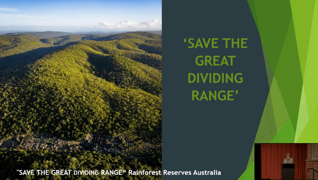
Please note the green areas on this map. It is such a small area. Please help to save it!
It is now more than 10 days since the massive rally at Ravenshoe, Far North Queensland, recorded by Nick Cater of the Menzies Research Centre. The question now arises as to whether Tania Plibersek, the Minister for the Environment and Water, will again postpone her decision on the fate of this extremely special forested area right next to the Wet Tropics World Heritage Area. The week before the rally, Ark Energy decided to submit a variation to their project. The project had been the subject of a Public Environmental Report. They even changed the name of the project. Locals still know it as Chalumbin Wind Farm. Locals have never confused the Wet Tropics World Heritage Area with the Ark Energy Project Site.
A map of the changes is given below, followed by my response to a Press Statement by Ark Energy. Lastly, I enclose the Statement itself in italics.
Copy of map on the project website
Last Ditch Stand by Ark Energy to Build the Chalumbin Wind Farm
It is only days before the Federal Environment Department were due to announce their decision about Ark Energy’s plan to build a wind farm near Ravenshoe in Far North Queensland. In their desperation, they have even renamed the wind farm and modified the project.
I have not been able to find any reference to the submitted design change or the name change on the EBPC site. I wonder if this is a back door route to keep other Ministers happy.
The site of the proposed wind development, whatever its name, lies within the catchment area of the Great Barrier Reef. Parts of the eastern boundary of the site are contiguous with the World Heritage Wet Tropics Area. This area was named by the IUCN as the second most valuable natural site in the world. It has been recognised for a long time that a much wider barrier protection area is needed next to the World Heritage Area. The ecological value of wet tropical forest is increased by the presence of wet sclerophyll and other forest beside it and should form connectivity between the sections of the World Heritage Area.
Ark Energy divided the proposed “Chalumbin wind farm” into two stages just before issuing the Public Environment Report for comment by the public.
Stage 1 turbines, roads and other infrastructure were mostly in dense, biodiverse forested areas. Stage 2 had areas of more open woodland where cattle grazed and there were some weed and pest infested areas. The forest and waterways of Stage 2 area were still of major importance from a biodiversity viewpoint but not as critical. As a last-ditch stand, Ark Energy has put in a variation of the project to government. If they had really wished to improve the impact of the project, it might have made sense to remove the turbines of Stage I and keep Stage 2.
But, No! Their new concept has basically removed turbines from the Stage 2 area and left the turbines of Stage 1. In other words, they have not removed the major environmental impacts of the proposed project but are making it sound as if they had. Their statements are extremely misleading and only careful perusal of their press release makes this apparent. It was not until we had a clear map of the turbine removal and remaining sites that the real situation could be seen. The press release states that the project completely avoids wet sclerophyll forest adjoining the World Heritage Area. Further information in the document states that “These changes reduce the impacts of the development to 0.7% of wet sclerophyll within 10 km of the project area.” These are carefully worded statements and are very misleading.
The claim is made that “After rehabilitation of the temporary construction disturbance the wind farm would have an operational footprint of approximately 57.6 hectares.” This suggests that full rehabilitation can happen relatively early and that the roads will be mostly rehabilitated. Even if rehabilitation planting could start immediately after the main construction phase, the restoration of actual habitat takes time. However, the roads are still needed for maintenance activities such as lubrication of the turbines, replacement of blades and ultimately removal of the entire wind turbine. I very much doubt that the area of cleared land will become only 57.6 hectares for a long time. In addition, about half a million tons of concrete would be used to form the bases for the turbines and these would not be removed or rehabilitated if the development was to go ahead. Neither will the deep scars on the landscape be rehabilitated.
The offsets are a joke as are so many other statements made in their press release. Offsets should be additional areas, not areas that are left alone. Actually, as I will explain in another blog, the “offset areas” may be subject to impact from the project. The impact assessments do not take into account the loss of soil water by the project.
Do not be fooled! Yet again Ark Energy showed pictures of cattle grazing in areas not impacted by the turbines, roads and other infrastructure. It should be remembered that the cattle stations range from heavily forested land to the east and open forest and pasture to the west.
The whole press statement has been written to make it sound as if they are really caring for our precious biodiversity when they are not. When our biodiversity is lost it is gone forever. It is not only the endangered species that are affected. There are no ways to rehabilitate or offset the loss.
By cutting down and dividing forest which currently works hard to sequester carbon, slow and clean and store water and cool the earth, the gains made by any renewable, unreliable electricity produced are greatly diminished. Indeed, the roads and the giant fan turbines will dry out large areas of forest and turn them into carbon sources rather than carbon sinks. It is quite possible that the carbon dioxide reductions afforded by wind power will be negated by the impact of the project itself. Will the forest itself be destroyed by poor climate change mitigation?
Media release Tuesday 5 September 2023
Controversial wind farm project in Queensland redesigned and renamed.
Environmental impacts reduced to low levels.
A proposed wind farm in north Queensland has shed its controversial name and responded to environmental concerns with a drastic redesign that halves its size.
The former Chalumbin Wind Farm has been renamed Wooroora Station Wind Farm, after its host property Wooroora Pastoral Station, a large cattle-grazing property, and has undergone a drastic redesign in response to concerns about the visual and construction impacts on the property, which is located next to national parks that form part of the Wet Tropics of Queensland World Heritage Area.
Forty-four of 86 wind turbines have been removed, halving the size of the project, and leaving a layout of 42 wind turbines. The new design includes a minimum buffer of 1 km to neighbouring World Heritage areas, and completely avoids wet sclerophyll forest adjoining the World Heritage Area as well as all known magnificent brood frog habitat.
A comprehensive nature positive plan includes rehabilitation of most of the construction disturbance and the establishment of magnificent brood frog nature reserves totalling 1,255 hectares. It also includes First Nations-led fire management and control of widespread feral pests (pigs, dogs, and cats) and invasive weeds, to improve the host property’s habitat for key species including the northern greater glider, masked owl, and spectacled flying-fox.
“These changes reduce the impacts to very low levels. We believe the benefits to the natural environment of this project far outweigh its impacts. Not least of them more clean energy into the grid in a relatively short time period and a significant improvement in habitat for protected species on private land adjacent to protected forests,” said Ark Energy General Manager Development for Queensland, Anthony Russo.
“After extensive public consultation, we have listened to feedback from the community, government, and the traditional owners, and made changes to the project to meet expectations. We look forward to working with all key stakeholders to achieve positive outcomes and we are committed to getting this project right from the outset and delivering on world’s best practice in the energy sector.
“We must navigate the tension between the construction required to transition to a clean energy system and protecting nature, and this project’s evolution offers an excellent case study of major design iterations to achieve nature positive outcomes.”
After rehabilitation of the temporary construction disturbance the wind farm would have an operational footprint of approximately 57.6 hectares.
It is hoped that the new name will also help to address a misunderstanding that the development could impact a nearby wilderness area also known as ‘Chalumbin’.
“Some opponents took advantage of the former name to spread misinformation and make unsubstantiated claims about what kind of habitat and species are in the project area and therefore the environmental impacts of the development. The reality is the project is NOT within the World Heritage area and it is important that the project is represented accurately, and the public have the facts,” said Mr Russo.
A variation has been lodged with the Department of Climate Change, Energy, the Environment and Water, which is currently assessing the proposal. More information on the project is available online at wooroorastationwindfarm.com.au
Humans have lived through a range of temperature changes. It is recent civilization that we are trying to save with people living all over the earth in great numbers needing a lot of energy not least in the form of food. We tend to forget how hard life was trying to have enough energy to survive even after we discovered fire. For most of our existence, the only way for a few individuals to get ahead a little was to use slaves or beasts of burden or warriors. These living energy sources were fed as little as possible or used as canon fodder. They rarely lived very long.
Then, only a few centuries ago, we discovered much more energy dense fossil fuels. Suddenly, we could abhor slave labour, care about animal welfare and we could all have good shelter and food. Poverty has been slowly disappearing in many parts of the world.
Our modern food production is very dependent on a stable climate. It is also very energy intensive. A few degrees of extra heat or a little less rain has devastating effects on production levels.
How do we balance energy needs with maintaining a stable climate? The critical action at this time is lowering greenhouse gas emissions. To do this, the biggest tasks are the electrification of many processes as possible, decarbonization of electricity generation and carbon capture and storage. What is the only energy efficient and cost-effective method of carbon capture and storage? As discussed in my previous blog natural systems are wonderful at carbon capture and storage. Let nature do its work!
Hydro, wind, solar, nuclear, and geothermal power plants all use up energy and produce relatively small amounts of carbon dioxide in their manufacture, construction, demolition, and recycling. Energy is used in the mining for their manufacture. Some require lots of backup storage or have other firming or conversion requirements. All require transmission lines.
What are Queensland’s Plans?
Queensland Government plans to deliver:
50% renewable energy target by 2030
30% emissions reduction below 2005 levels by 2030
70% renewable energy by 2032
80% renewable energy by 2035
zero net emissions by 2050.
Far North Queensland has two wind farms, Mt Emerald (180MW) and Windy Hill(24MW), with a third, the Kaban Green Power Hub under construction. Under Phase 1, the government has invested $40 million to upgrade the coastal 157 KV transmission infrastructure between Cairns and Townsville to 275KV. This investment will provide up to 500 MW of renewable energy connection potential in Far North Queensland. Several investors have shown interest in the area, with the $400 million 157 MW Kaban Wind Farm now under construction and expected to be operational this year. At Kaban there are 28 wind turbines which are 226m in height to the tip of the blade.
A photograph of Kaban Wind Farm taken Dec 2022. More roads and turbines can be seen in the distance.
Windy Hill has been running just over 20 years and has already needed to replace the wind turbine blades.
During the second half of last year, the Draft Public Environment Report was issued for the proposed Chalumbin Wind Farm on two grazing properties in Far North Queensland. These properties border the World Heritage Wet Tropics on the East and extend westward to the scattered woodland of the Einasleigh Uplands on the West. Early pictures of the site by Epuron showed cattle grazing in scattered woodland but in reality, most of the wind turbines were to be sited on mountain ridges close to the eastern boundary in dense eucalypt and transitional forest. The potential impacts from the project are substantial and wide-ranging including threats to endangered species and aboriginal cultural heritage.
The site of the proposed Chalumbin Wind farm.
Photos used in publicity about Chalumbin Wind Farm
Under the current Australian system, comments on a draft PER can only be submitted to the Project Proponent. The proponent then revises the document and sends the document plus the comments to The Federal Minister for the Environment. A decision on the Chalumbin project under the EPBC Act is yet to be issued and has already been postponed a few times. At one stage during the comment period, the Proponent put a full-page ad in the Cairns Post stating that they would welcome positive comments thus inferring that they would not accept negative comments.
A few locals have calculated the implications of the project from a carbon dioxide viewpoint. There were a number of omissions and critical mistakes in the Chalumbin PER about this topic such as equating carbon loads with carbon dioxide loads. This is a factor of 44 to 12.
Figures for the loss of forest carbon storage following clearance vary depending on the type of forest. The Chalumbin site is mostly pretty dense forest with good canopy cover for much of the areas where turbines are to be located. There are many trees with diameters of a metre or more. The carbon stored in these trees would be lost immediately if the trees are piled up and burnt or more slowly if the biomass is just allowed to rot.
Other losses following clearing include soil carbon, carbon from the roots and from soil biota. Estimates made on eucalypt plantations of soil carbon and root carbon loss suggest this can be double or more the above ground loss depending on the eucalypt species, the age of the trees and the rainfall.
Many studies suggest that natural forests are better at carbon sequestration than plantation eucalypts and that tropical wetter eucalypt forests are better still.
At Chalumbin, I have conservatively calculated that loss of carbon dioxide to the atmosphere during clearing will be about 2 million tonnes. Loss of sequestration over 20 years by this lost forest is 1.1 million tonnes or more. The carbon dioxide footprint of the wind turbines during their manufacture and transport to the site is about 300,000 tonnes. This is a total of 3.4 million tonnes.
The maximum savings in carbon dioxide made by replacing current power production with wind power at Chalumbin is 12 million tonnes of carbon dioxide over a period of 20 years assuming a capacity factor of 30%. The currently operating Mt Emerald Wind Farm has not achieved this capacity. So, this estimate should be dropped to 10 million tonnes or less.
This means that at least a third of the lowering of greenhouse gas emissions are lost by building a wind farm in this precious forest.
The losses don’t stop with Chalumbin.
Wind farm projects being proposed in the Wet Tropics Catchment Area are numerous and in areas of high biodiversity value, close to World Heritage areas and on the mountain ridges. This is death by a thousand cuts. The cumulative impacts from wind farm projects in the Wet Tropics Area will be unacceptability large and not usually considered.
Fragmentation of Forest and Edge Effects Destroy Biodiversity and Carbon Sequestration
Edge effects strongly affect forest microclimate, tree mortality, carbon storage and a diversity of fauna.
The hydrological regimes of fragmented landscapes differ markedly from those of intact forest. Desiccating conditions may penetrate up to 100m into areas near the roads. Streams in fragmented landscapes experience greater temporal variation in flow rate than do those in intact forests. Cleared areas have less evapotranspiration and rainfall interception and absorption by vegetation. Rapid runoff promotes localized flooding in the wet season and stream failure in the dry season, with potentially important impacts on aquatic animals.
Even narrow forest roads (20–30m) result in increased tree mortality and damage with wide-ranging alterations in the community composition of trees and undergrowth. Some insects and other fauna will not cross even narrow roads, yet hundreds of km of 70m or wider roads are being proposed.
If our forests are themselves at risk from Climate Change, forest fragmentation will accelerate the process.
Proposed Wind Farms Could Add Pollution to the Great Barrier Reef
Projects like Chalumbin lie on the head waters of the river catchments of the Wet Tropics Area. Hundreds of kms of unsealed 70-metre-wide roads that cross waterways have the potential to dump turbid water and other pollutants down rivers through areas of World Heritage Rain Forest out to the Great Barrier Reef. Farmers fear they will be blamed for the impacts.
We should remember that pollution accidents do happen. Wind turbines need lubricating and “oil changes” every 3 to 7 years. Over 200 litres of oil or synthetic lubricant is needed per turbine.
Building Wind Farms in Forests is a Terrible Waste
Forests are giant carbon and water storage batteries. Why discharge greenhouse gases to the atmosphere by land clearing and lose all the benefits forests provide in the mitigation of climate change? When they are gone, we lose all the carbon sequestration and cooling they do every day. Natural forests do this better than plantation forests.
By clearing forest to build wind farms, we lose a very substantial proportion of the carbon savings we would make by siting them elsewhere. A substantial proportion of what we gain in lower carbon emissions from wind power, we lose by destroying forests.
Even worse, we contribute to climate change through the loss of a range of mechanisms forests provide, long before any of the benefits of wind energy mitigate carbon emissions. This is needlessly making climate change worse in the short term which is the opposite to why we are setting 2030 targets.
We are also desecrating our irreplaceable biodiversity, Aboriginal cultural heritage, and tourist jobs in areas of high importance. High quality patches of remnant forest are rare and precious, and one proposed windfarm project area was being planned for inclusion in National Parks in the future. What a waste! We can fight climate change and protect our natural diversity at the same time. When our natural assets are gone, they are gone!
Loss of Forest Affects Cloud Formation and Alters the Hydrological Cycles
Loss of forest on mountain tops will lessen rainfall and lead to more droughts and flooding. While one project may have almost negligible impact on weather, many more wind farms are proposed. The wind farm projects change the land use from forest to major industrial, with major extensions to each project being possible with much less assessment. This will impact on both our World Heritage listed Wet Tropical Forests and Great Barrier Reef while drying our inland agricultural lands to the west. Good agricultural land is critical to our future.
In Conclusion
A substantial portion of the savings in carbon dioxide emissions made by using wind power are lost by building them in our precious forests. What a waste!
What worth do we put on the loss of biodiversity and ecosystems, stunning landscapes, natural carbon sequestration and storage. Forests cool the earth and make it rain. Forests soak up runoff like giant sponges and help prevent flooding, while recharging aquifers. They clean the water of pollutants so that most of the water going to the Great Barrier Reef is clean. Forest stabilises the soil so that turbid water does not kill frogs, fish, or corals.
We are putting so much at risk by building wind farms where they should not be.
I thought the goal was to fight climate change, not make it worse.
The photos in this blog are courtesy of Michael Seebeck and Steven Nowakowski
In my next blog I will provide more information about Queensland’s Energy and Jobs Plan, the Queensland SuperGrid.
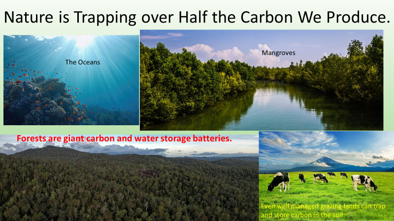
Worldwide, fossil fuel use spews about 37 billion tonnes of carbon dioxide into the atmosphere each year. Recent technologies have been used to determine just how much work forests do when storing carbon. Between 2001 and 2019, forests emitted an average of 8.1 billion metric tonnes of carbon dioxide per year from deforestation and other disturbances. At the same time, forests absorbed 16 billion metric tonnes of carbon dioxide per year.
Just imagine how much more efficient and cheaper it would be if existing forests were allowed to do their work in Queensland without disturbance. Denser forests and rapidly growing forests are particularly important. We should not forget that Queensland has nearly 40 % of Australia’s forests.
Hopefully, no one would argue that forests alone can save us from climate change, but they have a major role to play. If we do not protect forests as much as we can, we will suffer far worse climate change impacts.
It is not effective to “offset” greenhouse gas pollution from burning fossil fuels by storing carbon in forests. This is because fossil fuels are pumping much more carbon dioxide into the atmosphere than existing forests can absorb. At the same time, carbon stores in forests and other natural carbon sinks will become increasingly unstable as climate change progresses. Droughts, tropical storms, heatwaves and fire weather are increasing in severity and frequency because of climate change. This will continue to result in increases in forest losses, contributing to more and more carbon dioxide being released into the atmosphere. Risks are significantly reduced but not avoided by keeping the rise in global temperature well below 2°C.
The future
Protecting natural ecosystems and sustainably managing and re-establishing forests are important ways to reduce greenhouse gas emissions and slow down temperature rise in the short term by drawing down carbon dioxide from the atmosphere. At the same time, we must deeply and rapidly reduce global greenhouse gas emissions levels from fossil fuels – coal, oil and gas. If we do only the former and not the latter, we risk transforming more and more of our carbon sinks into carbon sources as climate change progresses.
Oh Dear! Yes, there is a risk that we could lose all our forests to Climate Change and that really would be Armageddon. Should we just stay on our current path and let it happen? Man has a tendency to picture the worst. It is an emotional response from our primitive brains. This type of thinking makes excuses and leads to a lack of appropriate action. Let’s just run around in circles instead, wasting money and time. /sarcasm
Why are forests vital?
Even now Earth’s forests are still capable of pulling nearly half the carbon dioxide produced by fossil fuels out of the atmosphere despite the clearing that has already happened. We must stop destroying our forests so that they can do this task to the greatest extent possible.
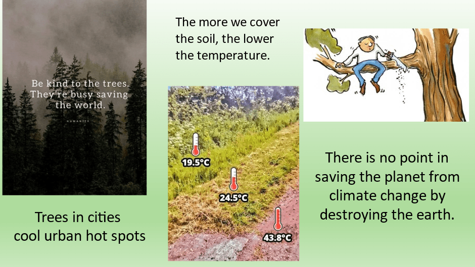
Forests keep the earth’s temperature down by 1°C or more. This happens in a number of ways. They shade the ground. They pull heat out of the atmosphere by using the sun’s rays for photosynthesis, they manufacture many products some of which they pass to the organisms in the soil in addition to wood formation. They also cool their surroundings using evapotranspiration, a technique similar to our evaporative coolers.
Forests are a very important part of the hydrological cycle and help to stabilise our climate in a number of ways. The soils below forests can be giant water sponges. This is particularly important on mountain ranges such as Australia’s Great Dividing Range. The water for rainfall passes down the mountain slopes much more slowly, preventing erosion and keeping our water clean and safe. The forest on mountain tops is important in cloud formation. It has been shown time and time again that rainfall is diminished if mountain tops are disturbed. In Australia this can lead to increased drought and flooding when it does rain.
As well as being a stabilising force for the climate, forests regulate ecosystems, protect biodiversity, play an integral part in the carbon cycle, and supply goods and services including shelter and food.
In order to maximise the climate benefits of forests,we must keep moreforest landscapes intact, manage them more sustainably, andrestore more of those landscapes which we have lost (from a recent IUCN statement).
What is Australia’s record? Nearly 50% of our forest cover has been cleared in the last two centuries, making Australia one of the worst developed countries for deforestation.
In Queensland about half of our recent clearing activity has been in catchment areas of the Great Barrier Reef particularly south of Townsville. WWF was not wrong when in December 2022 it stated that Queensland remains the land clearing capital of Australia.
Have we learnt any lessons? No, now we are threatening the densest eucalyptus forests clustering around our wet tropical rainforests near Cairns.
Australia’s best winds to drive wind turbines are found in the south-west. Places like Tasmania lie in the path of the Roaring 40s. Because the wind doesn’t always blow, a myth was set up that the wind would blow in these periods somewhere else and where better than the far north-east of Australia. The performance of existing wind farms in Far North Queensland is low at best and abysmal frequently. When the strong winds of the North come, we call them cyclones and the turbines will be shut down and are likely to suffer damage.
So, the current plan is to desecrate hard-working tropical forests to build poorly performing wind turbines. This is neither effective or efficient in money terms or in climate change mitigation terms.
The forest areas threatened by all the wind energy projects on the books or already being constructed are some of the most valuable in the world.
Here is just another of my slides.
There are alternatives to this rampant stupidity.
In my next blogs I discuss some of these projects in more detail. In the meantime, you might like to look at this brochure from Rainforest Reserves.
Queensland Government claims that our greenhouse emissions have reduced substantially since 2005. As I revealed in my last blog, it is only the reduction in land clearing that has reduced our reported emissions in a meaningful way.
Despite the substantial uptake and use of rooftop solar, our emissions from public electricity are still as high as ever.
It is our forests in Queensland that has been doing the hard work.
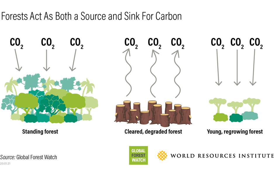
Sometimes, I read that many of the world’s forests are no longer carbon sinks or are heading that way. These statements can be misleading as they suggest forests are no longer working hard storing carbon. If a forested area has increasing areas that are cleared, the overall balance may be more like that of degraded land. Every time we clear, we reduce the forest’s ability to sequester carbon and release more carbon dioxide to the atmosphere from the felled trees and the soil.
Where are the forests in Queensland and which ones do the most work storing carbon? Unfortunately, some of the most important lie in Queensland’s designated Energy Zones for the building of “renewable” energy projects. This particularly applies in the Northern Renewable Energy Zone.
This blog presents a quick overview of Australian forests. My later blogs will examine the implications of the current energy zones in Queensland.
Forests provide many services to us. They are not just storing carbon.
Data on Forests
Australia has a total of 134 million hectares of forest, which is equivalent to 17% of Australia’s land area. Australia has about 3% of the world’s forest area, and globally is the country with the seventh largest forest area.
Queensland has the largest area of Australia’s forest (51.8 million hectares) – 39% of Australia’s forest. It has most of the tropical rainforest and mangroves plus a large proportion of Australia’s eucalypt forest.
Unfortunately, the classification and definitions of forest used by the Forestry Department are not quite the same as that used in the National Greenhouse Accounts and direct comparison of data can be misleading.
Most of Australia’s forests are native forests and these native forests are often divided into three classes based on their crown cover, and three classes based on mature tree height. Crown cover is the area of ground covered by tree canopies, ignoring any overlaps and gaps.
Less than a third of our forests are reasonably dense with more than 50% canopy cover. Rainforest is nearly three quarters closed canopy and of medium height.
Rainforest
Well over half of Australia’s rainforest is in Queensland. Australia has 3.6 million hectares of the rainforest native forest type, which is 2.7% of Australia’s total forest area. 50% is protected in nature conservation reserves with 2 million hectare belonging to Queensland.
Australia’s rainforests are typically characterised by high rainfall, lush growth and closed canopies. They rarely experience fire.
Rainforests are very important for the conservation of biodiversity. They provide habitat for many forest-dwelling and forest-dependent species of plants and animals. This includes numerous species that are endemic to Australia, and species listed as threatened under the Commonwealth Environment Protection and Biodiversity Conservation Act 1999.
Rainforest comprises only 2.7% of Australia’s total native forest, but provides habitat for 60% of Australia’s plant species, 60% of butterfly species, 40% of bird species and 35% of mammal species.
One third of Australia’s rainforests lie within UNESCO World Heritage Areas. The World Heritage Wet Tropical Forest clusters around Cairns. The IUCN nominated this forest as the second most important natural area in the world. At the time of its listing, it was noted that the forest was partially degraded and that every effort should be made to link the various sectors together.
Eucalypts
Three quarters of Australia’s total forest area is dominated by Eucalypt forest.
Please note that the denser eucalypt forest in Queensland lies just west of the wet tropical forests clustered around Cairns. The other main zone lies to the south of Emerald and Rockhampton. Various sectors of the denser forest are protected as National Parks and Forest Reserves.
Nearly 90% of the eucalypt forest in Queensland is either leasehold or privately owned. Much of it is the open woodland forest type and is often used for cattle grazing.
My next few blogs will discuss some of the other services forests do for us and how this fits into Queensland’s Energy Plan.
We have so much to do to meet the challenges of climate change. We only have limited time, money and resources. So, it becomes critical that we don’t act like headless chooks running around in circles wasting energy. Whatever we do needs to be efficient and well planned and evaluated.
Our public electricity production generates more carbon dioxide per unit of electricity than most of the developed world. On the positive side, our households generate and use a very high level of solar energy outside of the public system.
The Queensland Government reports that our greenhouse emissions have already fallen by 29% since 2005. Our target for 2030 is 30% below our emission levels in 2005. This suggests that we have almost reached our target. What is responsible for this decrease? It is all about clearing land.
The forests in Queensland are doing a great job of capturing and storing the carbon dioxide we produce. Perversely the decrease in the emission data is entirely due to the slowdown in the rate of forest clearing. When forests are cleared two changes occur. Firstly, there is less forest working hard on our behalf. Secondly, the felled trees and the soil beneath release their stored carbon back into the atmosphere.
Let’s look at some of the data.
How is Queensland going? Queensland’s carbon intensity of electricity consumption is currently almost 700 gCO2eq/kWh. Only a couple of areas in the world produce more carbon dioxide from the production of electricity per unit of electricity. Grant Chalmers presents this data on a regular basis.
For comparison, Tasmania only produces about 25 g of carbon dioxide per kilowatt-hour of electricity produced while South Australia manages an average of slightly more than 100 g per kilowatt-hour of electricity. However, during the night, South Australia hits 400 after the sun goes down when it still relies on the dirtiest form of electricity produced – Victoria’s brown coal.
Unfortunately, most data available from Government sources are a year older than Grant’s data. Grant’s data does not take into account electricity used directly from rooftop solar.
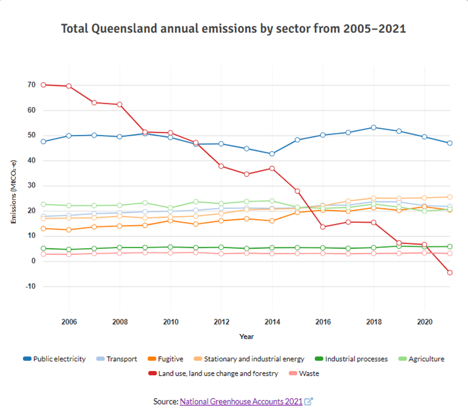
The graph below provides an overview of Queensland’s production of greenhouse gases.
Two sectors stand out: Land use, land-use change and forestry at -3.2% and public electricity producing nearly a third of the greenhouse gases. The graph below shows how the various sectors have changed over time.
Even the quickest of glances at the graph above shows that greenhouse gas emissions from most sectors have not changed much or even risen since 2005. But look at the fall from the land use, land use change and forestry sector: 70 to below zero. In 2005 about one third of Queensland’s greenhouse gas emissions came from the land use change. Our forests and well managed soils are now just counteracting the damage we are still doing by removing trees in forests but also on grasslands.